Methods
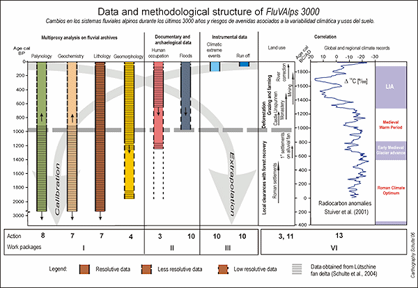
The methodological framework of the FluVAlps 3000 Project applies a multi-proxy approach based on the following work package (Figure 4):
- paleoecological fan delta proxies provided by fluvial archives, pollen records and geochronology (WP I)
- reconstruction of human occupation and floods on fluvial landforms from archaeological and documentary data (WP II)
- reconstruction and description of climate and hydrological extreme events based on written sources and instrumental data (WP III)
- cross calibration of the paleoecological data, written sources and instrumental data considering
- social-environmental interactions
- development of past models and future scenarios of environmental changes (WP IV)

Figure 4: Data and methodological structure of the FluVAlps 3000 Project. Based on previous research work (work package I, II and VI) the present approach integrates studies of recent and historical floods from instrumental and documentary data (WP II and IV). The calibration of the natural proxies by these sources may improve data quality and provide in the future a accurate data base for hydrological models of extreme events (© L. Schulte, 2006).
Natural archives
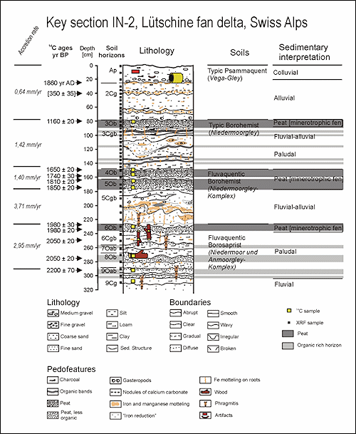
The Late Holocene depositional history of the Lütschine, Lombach and Kander fan deltas will be reconstructed using a multi-proxy approach that combines different methods from several disciplines such as sedimentology, geomorphology, palynology, and geochronology. The first group of analyses focuses on sedimentary changes in several key sections (Figure 5); the second group covers spatial changes in the fan morphology; the third group investigates the variability of the local vegetation; and the last group deals with the use of proxy-data sets from the fan deltas as an integrated fluvial paleoclimate record.

Figure 5: Lithostratigraphy of key section IN-2, central Lütschine fan delta (Swiss Alps) according to Schulte et al. (2006, 2007). The 90-m-wide exposed IN-2 key section records a detailed sequence of organic-rich paludal sediments deposited from 2200+/-70 to 1980+/-30 yr BP, four peat horizons dated to 1980+/-30, 1810+/-20, 1650+/-20 and 1160+/-20 yr BP, separated by fluvial and paludal sediments, and alluvial deposits at the top. This general stratigraphic framework and lateral extension of the specific units can also be traced from other key sections, as well as, to a less degree, from cores.
The fan delta deposits are sampled at several key sections located in exposures (in some cases up to 200 m wide) and from drillings down to a depth of 17 m along cross-sections. Sediments and soil horizons are described, and trunk, plant and mollusc fragments are collected and classified. Micromorphological analysis of soil thin sections provides insights into sediment structures and associated geomorphic processes. Furthermore, sedimentological records from the fan delta are obtained by examining 135 core inventories provided by the Hydro and Energy Power Office of the Canton of Berne, showing lateral extension of key horizons.
To study the geochemical variability of the alluvial fan sediments, major and trace elements of samples extracted from key sections are determined by X-ray fluorescence. The statistical treatment of the geochemical datasets - i.e. factor analysis (FA) and correlation - are computed applying the statistical ADE-4 programme library. Samples for pollen analysis are taken at intervals from 5 cm to 10 cm in key sections. To calculate AP/NAP percentages, we exclude Asteraceae, Cyperaceae and crop taxa from the base sum. The results are plotted and treated in a pollen diagram using the Tilia software.
An accurate geomorphic interpretation of the sedimentation units in the key sections requires reconstruction of the changes of the river channels. The channel locations as reconstructed from historical maps and were compared with "fluvial traces" such as filled palaeochannel and meandering field boundaries identified through fieldwork, SPOT image and aerial photograph survey.
Finally, the different alluvial fan proxies, i.e. lithology, geochemistry, geomorphology and pollen are compared with global climate records.
Written sources and instrumental data
Historical maps published between 1496 and 1900 are studied with regard to the number and location of channel branches on the fan deltas. Furthermore, literature on Swiss historical cartography are quoted regarding the distinction of maps considered primary sources from maps that are based on copies or integrate earlier cartographies. The inventories of historical buildings and archaeological sites of the Canton of Berne, compiled by the Cantonal Office for the Preservation of Historical Buildings and Monuments and the Archaeological Survey provide information about occupation of the floodplain. The location of historical buildings and archaeological sites contribute to define maximum ages of the ancient river branches derived from geomorphological survey.
To analyse the temporal evolution of the alpine rivers, data base of the Hydro and Energy Power Office of the Canton of Berne, documents (chronicles, etc.) of municipal, cantonal and federal archives, early instrumental data and the most recent meteorological information are consulted. The reconstruction of historical floods requires the location of flood damages and flood marks, control of floodplain topography and hydraulic modelling.
Schulte, L. et al. 2019.
Integration of multi-archive datasets towards the development of a four-dimensional paleoflood model in alpine catchments.
Global and Planetary Change 180, 66-88.
Peña, J.C.; Schulte, L., 2020.
Simulated and reconstructed atmospheric variability and their relation with large Pre-industrial summer floods in the Hasli-Aare catchment (Swiss Alps) since 1300 CE.
Global and Planetary Change 190, 103191.
Schulte, L. et al., 2019.
Pluridisciplinary analysis and multi-archive reconstruction of paleofloods: societal demand, challenges and progress.
Global and Planetary Change 177, 225-238.
Blöschl, G. et al. 2020.
Current European flood-rich period exceptional compared with past 500 years.
Sánchez-García et al. 2019.
500-year flood history in the arid environments of south-eastern Spain. The case of the Almanzora River.
Global and Planetary Change, 102987.
Schulte, L. et al. 2015.
A 2600-year history of floods in the Bernese Alps, Switzerland: frequencies, mechanisms and climate forcing.
Hydrology and Earth System Sciences 19, 3047-3072.
Peña, J.C. et al. 2015.
Influence of solar forcing, climate variability and atmospheric circulation patterns on summer floods in Switzerland.


