Regional settings
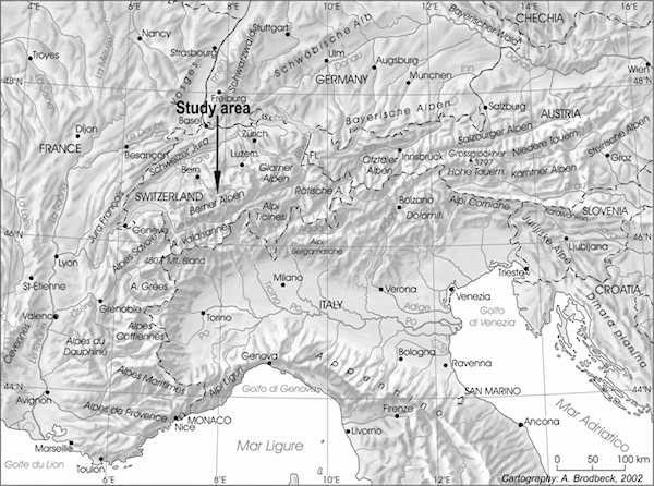
The Alps, which form a border between the humid mid-latitudes under Atlantic influence, to the north, and the Mediterranean subtropical zone, to the south, are especially sensitive to events of extreme precipitation and disastrous floods, and to changes in the circulation of the atmosphere at the global scale (Figure 6). Natural paleofloods are known to have resulted from excessive rainfall intensity and frequency, snow melt, glacier melt, precipitation combined with frozen soils, and other phenomena. Land use, as well, can substantially modify mountain ecosystems and the dynamics of river systems. Despite important progress in Holocene paleoclimate and paleo-environmental studies in the Alps during the last years, the knowledge of Alpine river dynamics and their chronology is still limited. To address the influence of external factors, such as climatic variability and land use, on aggradation and floods, we focused our research on the Late Holocene sedimentary and geomorphologic history of the fan deltas and alluvial fans of the Lütschine, Lombach, Kander river and further small catchments of the Lake Brienz and Thun area at the northern slope of the Jungfrau massif (4274 m a.s.l.).

Figure 6: Location of the Lütschine catchment in the north-western Alps. Recent paleoclimate records from dendrochronological and instrumental data compiled by the ALPIMP Project (2006) showed different pluviometric trends between the humid mid-latitudes north-western Alps and the Mediterranean influenced south-eastern Alps from 1800 yr AD to present.
The choice of the fan deltas of the Lake Brienz and Thun area (46°40’N, 7°53’E) in the Berner Oberland for case studies has several reasons: first, its strategic location on the northern slope of the Swiss Alps; second, the spatial coexistence of wetland, alluvial and fluvial environments on a low-gradient fan delta in connection with a lake generating a high-resolution fluvial record; third, the specific spatial lithological settings of crystalline and carbonated sedimentary rocks (Lütschine and Kander catchment); fourth, the availability of high-resolution flood records from the Swiss Alps and the Rhine catchment for the last centuries based on documentary and instrumental data, along with high-resolution glacier proxies from the Lower Grindelwald Glacier (Lütschine catchment) for the Late Holocene; and, finally, in the case of the Lütschine and Lombach fan the existence of exceptional exposures and their accessibility.

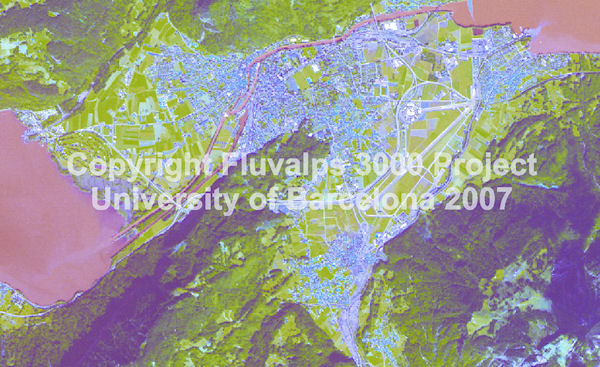
Figure 8: SPOT Image (G, R, IR; 30.08.2005; decorrelation strech) showing the Lütschine fan delta transformed by aggradation processes (greyish areas) during the catastrophic flood of August 22nd, 23rd and 24th of 2005. Copyright Fluvalps 3000.
The 379-km2 catchment of the Lütschine river is divided into the Lauterbrunnen valley and the Lütschen valley. Instrumental hydrological data recorded since 1924 at the Gsteig gouging station, located at the apex of the fan delta, indicate a nival-glacial regime. The mean discharge is 18.8 m3 s-1, whereas the maximum discharge was around 190 m3 s-1 in 1948 and 2000 and reached 264 m3 s-1 on 22 August 2005 - the highest discharge measured during the last two centuries (release of the Federal Office for Water and Geology). In the northern Swiss Alps floods have mainly been triggered by precipitation anomalies, pronounced snow melt caused by warm fronts, and lake outbursts. Annual precipitation ranges from 1175 mm yr-1 at Interlaken to 2800 mm yr-1 at the highest elevation of the Jungfrau massif. The alpine and subalpine landscapes of the drainage basins are influenced by fairly intensive land use (pasture and tourism). Regarding the present land cover, 44% of the Lütschine catchment is wasteland, 37% meadows, 17% forest, and only 2% is built land.
Schulte, L. et al. 2019.
Integration of multi-archive datasets towards the development of a four-dimensional paleoflood model in alpine catchments.
Global and Planetary Change 180, 66-88.
Peña, J.C.; Schulte, L., 2020.
Simulated and reconstructed atmospheric variability and their relation with large Pre-industrial summer floods in the Hasli-Aare catchment (Swiss Alps) since 1300 CE.
Global and Planetary Change 190, 103191.
Schulte, L. et al., 2019.
Pluridisciplinary analysis and multi-archive reconstruction of paleofloods: societal demand, challenges and progress.
Global and Planetary Change 177, 225-238.
Blöschl, G. et al. 2020.
Current European flood-rich period exceptional compared with past 500 years.
Sánchez-García et al. 2019.
500-year flood history in the arid environments of south-eastern Spain. The case of the Almanzora River.
Global and Planetary Change, 102987.
Schulte, L. et al. 2015.
A 2600-year history of floods in the Bernese Alps, Switzerland: frequencies, mechanisms and climate forcing.
Hydrology and Earth System Sciences 19, 3047-3072.
Peña, J.C. et al. 2015.
Influence of solar forcing, climate variability and atmospheric circulation patterns on summer floods in Switzerland.


